
Texas Map
 |
 |
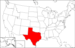
Where Is Texas?
The State of Texas is highlighted in red on this map. Texas is bounded by Oklahoma on the north, and by Louisiana on the east. It is bordered by Arkansas on the northeast, by the Gulf of Mexico on the southeast, by New Mexico on the northwest, and by Mexico on the southwest.
Texas Maps
Texas is the 2nd largest state in the United States, covering a land area of 261,797 square miles (678,054 square kilometers). Texas is divided into 254 counties, many of which have Hispanic names. This Texas map site features road maps, topographical maps, and relief maps of Texas. The detailed, scrollable road map displays Texas counties, cities, and towns as well as Interstate, U.S., and Texas state highways. The pannable, scalable Texas street map can be zoomed in to show local streets and detailed imagery.
Texas Highway Map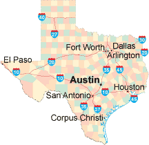 Click on the highway map thumbnail
to view a scalable Texas road map. |
TX Topo Map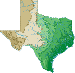 Click map to enlarge.
|
TX Relief Map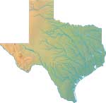 Click map to enlarge.
|
The detailed Texas map and the regional Texas map display cities, roads, rivers, and lakes as well as terrain features. The detailed map shows only the State of Texas, while the regional map shows Texas and the surrounding region.
Texas Infrastructure > Texas Airports
In 2005, the population of Texas was estimated at 22,928,508, which is about 87.3 people per square mile. In 2010, Texas' population rose to 25,145,561 people. More recently, in the 2020 census, the Texas population was 29,145,505. The state's major Interstate Highways include I-10, I-20, I-30, I-35, and I-45.
Texas Topography
Texas is derived from the Caddo Indian word "teysha" or "tejas", which means "friend" or "hello friend". The southeast Texas terrain consists of Gulf Coast barrier islands and cypress swamps, gradually rising to a coastal plain. The cliffs along the Balcones Escarpment in central Texas mark the eastern edge of the Texas hill country, which gradually merges into prairie country in northern and western Texas. Popular visitor attractions include Big Bend National Park, Padre Island National Seashore, and Johnson Space Center in Houston.
For Texas travel and tourism information, visit the official Texas tourism site and Texas Atlas.
Other Maps of Texas
This Texas reference map shows major cities, roads, railroads, and physical features in Texas.Several map publishing companies offer printed maps of Texas. For example, Omni Resources offers several maps of Texas that feature points of interest, airports, and parks, as well as selected local attractions and insets of major Texas cities.
All rights reserved.
Certain maps hereon are © Map Resources or Digital Wisdom.
To facilitate browsing, certain external links will open in new windows.
Texas-Map.org Editor, State Maps, PO Box 828, Barnegat, NJ 08005.